
辛頓隕擊坑
 辛頓隕石坑及附近其他隕坑的激光高度計地圖,顏色代表高程。 | |
| 行星 | 火星 |
|---|---|
| 坐標[broken anchor] | 40°43′N 328°21′W / 40.72°N 328.35°W |
| 火星方格列表 | 伊斯墨紐斯湖區 |
| 直徑 | 65.25公里 |
| 命名 | 威廉·梅爾茲·辛頓 |
辛頓隕擊坑(Sinton)是火星伊斯墨諾斯湖區位於北半球巨大的李奧撞擊坑南面的一座撞擊坑[1],其中心坐標為北緯40.72度、西經328.35度,直徑65.25公里,名稱取自美國哈佛天文學家威廉·梅爾茲·辛頓(1925年-2004年),2007年被國際天文聯合會行星系統命名工作組批准接受[2]。
描述[編輯]
據信辛頓隕擊坑是由隕石撞擊在冰原所造成,這次撞擊融化了大量地下積冰並產生出許多分支河谷,其中一些可在下面的一幅圖像中看到[3]。冰原的證據來自該地區分佈的線狀谷底沉積(LVF)和舌狀岩屑坡(LDA),其中的一些也可在下面的圖像中看到[4][5][6][7]。
-
 火星勘測軌道飛行器背景相機拍攝的辛頓隕擊坑西側邊緣。
 -
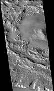
 辛頓隕石坑南面的河道,這些都是撞擊發生在地下富含積冰的表面時所產生。註:這是前一幅照片的放大版。
 -
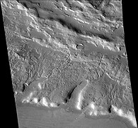
 辛頓隕擊坑北部的古冰川,是該地區眾多冰川之一。註:這是前面照片的放大版。


另請查看[編輯]
參考文獻[編輯]
- ^ Moore, P. et al. 1990. The Atlas of the Solar System. Crescent Books. NY
- ^ Gazetteer of Planetary Nomenclature | Sinton. usgs.gov. International Astronomical Union. [5 March 2015]. (原始內容存檔於2022-05-06).
- ^ Morgan, G., J. Head. Sinton Crater, Mars: Evidence for impact into a plateau icefield and melting to produce valley networks at the Hesperin-Amazonian boundary. Icarus: 202, 39-59.
- ^ Lucchitta, B. 1984. Ice and debris in the fretted terrain, Mars. J. Geophys. Res. Suppl. 89, 409.
- ^ Head, J. et al. 2006. Extensive valley glacier deposits in the northern mid-latitudes of Mars: Evidence for Late Amazonian obliquity-driven climate change. Earth Planet. Sci. Lett. 241, 663-671.
- ^ Head, J., et al. 2006. Modification of the dichotomy boundary on Mars by Amazonian mid-latitude regional glaciation. Geophys. Res. Lett. 33, L08S03, doi:10.1029/2005GL024360.
- ^ Morgan, G, J. Head, D. Marchant. 2009. Lineated Valley Fill (LVF) and Lobate Debris Aprons (LDA) in the Deuteronilus mensae northern dichotomy boundary region, Mars: Constrains on the extent, age, and episodicity of Amazonian glacial events. Icarus: 202, 22-38.