使用者:Addis-Bot/township/Category:Townships in Ohio by county/Sandy Township, Stark County, Ohio
| Sandy Township, Stark County, Ohio | |
|---|---|
| 鎮區 | |
 American Landfill looms over Sandy Township | |
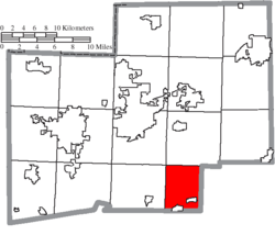
 Location of Sandy Township in Stark County | |
| 國家 | 美國 |
| 州份 | 俄亥俄州 |
| 縣 | Stark |
| 面積 | |
| • 總計 | 20.6 平方英里(53.3 平方公里) |
| • 陸地 | 20.6 平方英里(53.3 平方公里) |
| • 水域 | 0.0 平方英里(0.0 平方公里) |
| 海拔[1] | 971 英尺(296 公尺) |
| 人口(2000年) | |
| • 總計 | 3,679人 |
| • 密度 | 178.9人/平方英里(69.1人/平方公里) |
| 時區 | 東部(EST)(UTC-5) |
| • 夏時制 | EDT(UTC-4) |
| FIPS代碼 | 39-70436[2] |
| 地名信息系統特徵識別碼 | 1086989[1] |
Sandy Township is one of the seventeen townships of Stark County, 俄亥俄州, 美國. The 2010 census found 3,675 people in the township;[3] this was a slight decrease from the 2000 census, which found 3,679 people in the township, 2,059 of whom lived in the unincorporated portions of the township.[4]
地理[編輯]
Located in the southern part of the county, 與以下鎮區接壤:
- Osnaburg Township - 北
- Brown Township, Carroll County - 東
- Rose Township, Carroll County - 南
- Sandy Township, Tuscarawas County - 南west corner
- Pike Township - 西
- Canton Township - 北west corner
Two villages are located in Sandy Township: part of Magnolia in the south, and Waynesburg in the southeast.
Name and history[編輯]
Statewide, the only other Sandy Township is located in Tuscarawas County.
On March 16, 1809, the Stark County commissioners divided the county into townships. "Sandy Township (election at the residence of Isaac Van Meter), to include the fifteenth and sixteenth townships in the sixth range and sixteenth and seventeenth townships in the seventh range."[5] Brown Township was formed in 1815, Harrison Township in 1817, and Rose Township in 1818, leaving Sandy Township as Survey township 17 of range 7.[6] With the formation of Carroll County in 1833, two miles off the east side of the township were annexed to Brown Township, leaving a four mile wide township.[7]
In 1833, Sandy Township contained two gristmills, four saw mills, one fulling mill, and three stores.[8]
政府[編輯]
鎮區有3人組成的理事會管理。理事會理事選舉在奇數年11月舉行,並在來年1月1日開始四年任期。兩名理事的選舉在總統選舉後一年舉行,另一名的選舉在總統選舉前一年舉行。鎮區財務官亦由選舉產生[9],與一名鎮區理事選舉同時舉行,不過在來年4月1日才開始四年任期。若財務官或理事職位有空缺,將由剩餘理事填補。
參考資料[編輯]
| 歷史人口數 | |||
|---|---|---|---|
| 調查年 | 人口 | %± | |
| 1820年 | 509 | — | |
| 1830年 | 909 | 78.6% | |
| 1840年 | 1,265 | 39.2% | |
| 1850年 | 1,270 | 0.4% | |
| 1860年 | 1,044 | −17.8% | |
| 1870年 | 1,116 | 6.9% | |
| 1880年 | 1,265 | 13.4% | |
| 1890年 | 1,171 | −7.4% | |
| 1900年 | 1,417 | 21.0% | |
| 1910年 | 1,624 | 14.6% | |
| 1920年 | 1,875 | 15.5% | |
| 1930年 | 2,315 | 23.5% | |
| 1940年 | 2,772 | 19.7% | |
| 1950年 | 3,587 | 29.4% | |
| 1960年 | 4,326 | 20.6% | |
| 1970年 | 4,115 | −4.9% | |
| 1990年 | 3,630 | — | |
| 2000年 | 3,679 | 1.3% | |
| 2010年 | 3,675 | −0.1% | |
| [10] | |||
- ^ 1.0 1.1 US Board on Geographic Names. United States Geological Survey. 2007-10-25 [2008-01-31].
- ^ American FactFinder. United States Census Bureau. [2008-01-31].
- ^ Ohio Department of Development
- ^ Stark County, Ohio — Population by Places Estimates Ohio State University, 2007. Accessed 15 May 2007.
- ^ Perrin, William Henry (編). History of Stark County, with an outline sketch of Ohio. Chicago: Baskin and Battey. 1881: 204. OCLC 23276454.
- ^ Perrin 1881 : 205
- ^ Perrin 1881 : 469
- ^ Kilbourn, John. The Ohio Gazetteer, or, a Topographical Dictionary. Scott and Wright: 409. 1833 [12 December 2013].
- ^ §503.24, §505.01, and §507.01 of the Ohio Revised Code. Accessed 4/30/2009.
- ^ census data: 1820 : 1820 page 137 , 1830 : Kilbourn, John. The Ohio gazetteer: or, Topographical dictionary: describing the several ... in the State of Ohio. self. 1831: 332. , 1840, 1880 : Howe, Henry. Historical Collections of Ohio, The Ohio Centennial Edition. The State of Ohio. 1907: 285. , 1850, 1860, 1870 : 1870 page 35 , 1890, 1900 : Hunt, William C. Population of the United States by states and territories, counties, and minor Civil Divisions, as returned at the Twelfth Census: 1900. United States Census Printing Office. 1901: 318. , 1910, 1920, 1930 : 1930 page 56 , 1940, 1950 : 1950 page 21 , 1960, 1970 : 1970 page 135 , 1990 : 1990 , 2000 : 2000
