File:Soldiers-Home-Lincoln-Cottage.jpg

頁面內容不支援其他語言。
這個檔案來自維基共享資源
維基百科,自由的百科全書

原始檔案(798 × 678 像素,檔案大小:152 KB,MIME 類型:image/jpeg


此圖片所涉及之地點或建築現被列入美國的國家史蹟名錄。其登錄號為 7001237.

摘要

描述 U.S. Soldiers Home, Corn Rigs (Lincoln Cottage), Rock Creek Church Road & Upshur Street Northwest, Washington, D.C. Main façade, oblique view. Now the centerpiece of President Lincoln and Soldiers' Home National Monument. Approximate coordinates: 38°56′30″N 77°0′42″W / 38.9417°N 77.01167°W / 38.9417; -77.01167.
日期
來源
本圖像可以從美國國會圖書館的圖片與照片組獲得,其編號為hhh.dc0445
此標籤不表示文件的著作權狀態。任何文件在附有此標籤的同時還需要一個有效的著作權標籤請參閱許可協議說明頁面以了解更多資訊。

العربية  беларуская (тарашкевіца)  বাংলা  čeština  Deutsch  English  español  فارسی  suomi  français  galego  עברית  magyar  Bahasa Indonesia  italiano  日本語  lietuvių  македонски  മലയാളം  Nederlands  polski  português  português do Brasil  română  русский  sicilianu  slovenčina  slovenščina  Türkçe  українська  简体中文  繁體中文  +/−

作者
Jack Boucher  (1931–2012)  wikidata:Q6111338
 
別名
Jack E. Boucher; Jack Edward Boucher
描述 美國攝影師和architectural photographer
HABS, HAER and HALS photographer, National Park Service
出生/逝世日期 1931年9月4日 在維基數據編輯 2012年9月2日 在維基數據編輯
出生/逝世地點 水牛城 Holy Cross Hospital
作品年代 從1949年到2009年
創作地點
權威檔案
creator QS:P170,Q6111338
授權許可
(重用此檔案)
This file comes from the Historic American Buildings Survey (HABS), Historic American Engineering Record (HAER) or Historic American Landscapes Survey (HALS). These are programs of the National Park Service established for the purpose of documenting historic places. Records consist of measured drawings, archival photographs, and written reports.


When reusing please credit: Library of Congress, Prints & Photographs Division, DC,WASH,534D-4
此標籤不表示文件的著作權狀態。任何文件在附有此標籤的同時還需要一個有效的著作權標籤請參閱許可協議說明頁面以了解更多資訊。

Public domain This image or media file contains material based on a work of a National Park Service employee, created as part of that person's official duties. As a work of the U.S. federal government, such work is in the public domain in the United States. See the NPS website and NPS copyright policy for more information.
目標地點38° 56′ 10.85″ 北, 77° 00′ 32.59″ 西 Kartographer map based on OpenStreetMap.位於此地的本圖片與其他圖片: OpenStreetMapinfo
這是一張修飾過的圖片,即本圖片是用軟體修改過後的版本,修改的方式或內容有:cropped

說明

添加單行說明來描述出檔案所代表的內容

在此檔案描寫的項目

描繪內容

描述地坐標 中文 (已轉換拼寫)

38°56'10.849"N, 77°0'32.591"W

檔案歷史

點選日期/時間以檢視該時間的檔案版本。

日期/時間縮⁠圖尺寸使用者備⁠註
目前2006年4月26日 (三) 18:28於 2006年4月26日 (三) 18:28 版本的縮圖798 × 678(152 KB)Eoghanacht
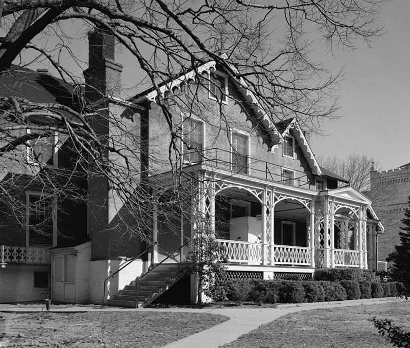
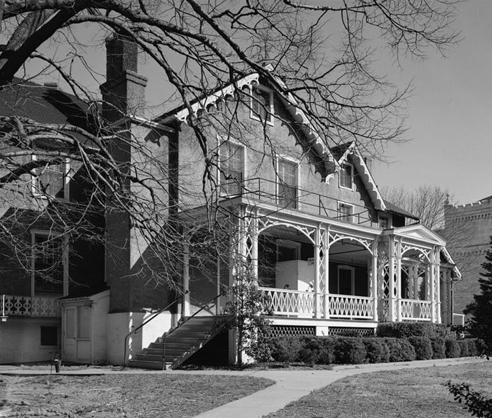
{{Information| |Description=U.S. Soldiers Home, Corn Rigs (Lincoln Cottage), Rock Creek Church Road & Upshur Street Northwest, Washington, D.C. Main façade, oblique view. Now the centerpiece of [w:President Lincoln and Soldiers' Home National Monument|

下列頁面有用到此檔案:

全域檔案使用狀況