
File:Map indicating Baffin Island, Nunavut, Canada.png
此為最大尺寸。
Map_indicating_Baffin_Island,_Nunavut,_Canada.png (428 × 380 像素,檔案大小:74 KB,MIME 類型:image/png)
摘要
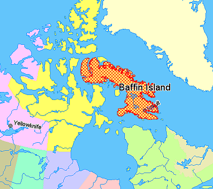
Map indicating Baffin Island, Nunavut, Canada.
Nunavut
Greenland
Quebec
Newfoundland and Labrador
Northwest Territories
Alberta
Saskatchewan
Manitoba
Ontario
© Her Majesty the Queen in Right of Canada, Department of Natural Resources. All rights reserved.
Licence Agreement
授權條款

|
本作品的著作权持有者允许任何人以任何目的使用该作品,包括无限制的再分发、商业性使用和修改内容。
使用注意:
|
檔案歷史
點選日期/時間以檢視該時間的檔案版本。
| 日期/時間 | 縮圖 | 尺寸 | 使用者 | 備註 | |
|---|---|---|---|---|---|
| 目前 | 2006年3月21日 (二) 11:55 | | 428 × 380(74 KB) | David Kernow~commonswiki | == Summary == Map indicating Baffin Island, Nunavut, Canada. {{legend|#ffff66|Nunavut}} {{legend|#ffffcc|Greenland}} {{legend|#d5fe94|Quebec}} {{legend|#ecebb6|Newfoundland and Labrador}} {{legend|#ffccff|Northwest Territories}} {{leg |
| 2006年3月21日 (二) 11:53 |  | 428 × 380(19 KB) | David Kernow~commonswiki | == Summary == Map indicating Coronation Gulf, Nunavut, Canada. {{legend|#ffff66|Nunavut}} {{legend|#ffffcc|Greenland}} {{legend|#d5fe94|Quebec}} {{legend|#ecebb6|Newfoundland and Labrador}} {{legend|#ffccff|Northwest Territories}} { |
檔案用途
下列頁面有用到此檔案:
全域檔案使用狀況
以下其他 wiki 使用了這個檔案:
- bg.wikipedia.org 的使用狀況
- cs.wikipedia.org 的使用狀況
- en.wikipedia.org 的使用狀況
- en.wikinews.org 的使用狀況
- fi.wikipedia.org 的使用狀況
- pl.wiktionary.org 的使用狀況
- pt.wikipedia.org 的使用狀況