
File:Map-NDB.svg

此 SVG 檔案的 PNG 預覽的大小:707 × 600 像素。 其他解析度:283 × 240 像素 | 566 × 480 像素 | 905 × 768 像素 | 1,207 × 1,024 像素 | 2,414 × 2,048 像素 | 2,621 × 2,224 像素。
原始檔案 (SVG 檔案,表面大小:2,621 × 2,224 像素,檔案大小:713 KB)
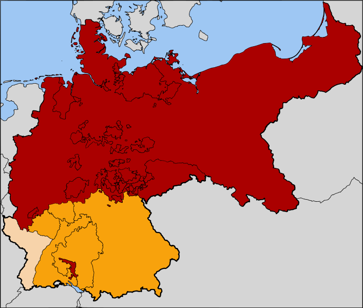
| 描述 | The North German Confederation / Norddeutscher Bund (1867–1871) in red. The states that would join the confederation and form the German Empire are in orange. Alsace-Lorraine, the territory annexed from France following the Franco-Prussian War of 1871, is in a paler orange. |
| 日期 | |
| 來源 | Based on map data of the IEG-Maps project (Andreas Kunz, B. Johnen and Joachim Robert Moeschl: University of Mainz) - http://www.ieg-maps.uni-mainz.de |
| 作者 | User:52 Pickup |
| 授權許可 (重用此檔案) |
此檔案採用創用CC 姓名標示-相同方式分享 2.5 通用版授權條款。
|
檔案歷史
點選日期/時間以檢視該時間的檔案版本。
| 日期/時間 | 縮圖 | 尺寸 | 使用者 | 備註 | |
|---|---|---|---|---|---|
| 目前 | 2007年7月25日 (三) 06:11 | | 2,621 × 2,224(713 KB) | 52 Pickup | now with Alsace-Lorraine coloured in |
| 2007年7月24日 (二) 07:37 |  | 2,621 × 2,224(713 KB) | 52 Pickup | oops, wrong version | |
| 2007年7月24日 (二) 07:36 |  | 2,621 × 2,224(713 KB) | 52 Pickup | {{Information| |Description= The North German Confederation / Norddeutscher Bund (1867-1871) in red. The states that would join the confederation to form the German Empire |
檔案用途
下列頁面有用到此檔案:
全域檔案使用狀況
以下其他 wiki 使用了這個檔案:
- ar.wikipedia.org 的使用狀況
- ast.wikipedia.org 的使用狀況
- azb.wikipedia.org 的使用狀況
- az.wikipedia.org 的使用狀況
- be.wikipedia.org 的使用狀況
- ca.wikipedia.org 的使用狀況
- cs.wikipedia.org 的使用狀況
- da.wikipedia.org 的使用狀況
- de.wikipedia.org 的使用狀況
- en.wikipedia.org 的使用狀況
- es.wikipedia.org 的使用狀況
- et.wikipedia.org 的使用狀況
- fa.wikipedia.org 的使用狀況
- fr.wikipedia.org 的使用狀況
- gl.wikipedia.org 的使用狀況
- hu.wikipedia.org 的使用狀況
- hy.wikipedia.org 的使用狀況
- it.wikipedia.org 的使用狀況
- ja.wikipedia.org 的使用狀況
- ka.wikipedia.org 的使用狀況
- ko.wikipedia.org 的使用狀況
- lv.wikipedia.org 的使用狀況
- mk.wikipedia.org 的使用狀況
- ms.wikipedia.org 的使用狀況
- pl.wikipedia.org 的使用狀況
檢視此檔案的更多全域使用狀況。