
File:Port Phillip 10,000.PNG
此為最大尺寸。
Port_Phillip_10,000.PNG (514 × 523 像素,檔案大小:20 KB,MIME 類型:image/png)

|
此檔案是透過機器人腳本從en.wikipedia移動到維基共享資源的。來源中的所有資訊均已保留,但仍需要人工的審閱。部分或所有的資訊可能會出現在錯誤的區域;只有在經過審閱並修正需改正的錯誤後,此檔案的相關資訊才能視為可使用。當審閱結束後,請移除本模板,更詳細的資訊參見下方。 現在就開始檢查! |
摘要
| 描述 |
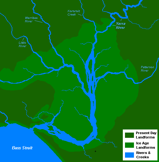
English: A very basic map of the port phillip plains approximately 10-12 thousand years ago, prior to sea level rise that filled the area of land now known as Port Phillip, and the course of the Yarra River as it emptied into Bass Strait. More exact details regarding the course of the Yarra River in the port phillip plains are needed. |
| 日期 | 2008年十一月13日 (原始上傳日期) |
| 來源 | 自己的作品 |
| 作者 | 英文維基百科的Nick carson |
授權條款
| 此作品已由其作者,英文維基百科的Nick carson,釋出至公有領域。此授權條款在全世界均適用。 這可能在某些國家不合法,如果是的話: Nick carson授予任何人有權利使用此作品於任何用途,除受法律約束外,不受任何限制。 |
原始上傳日誌
The original description page was here. All following user names refer to en.wikipedia.
- 2008-11-13 14:20 Nick carson 514×523 (20321 bytes) A very basic map of the port phillip plains approximately 10-12 thousand years ago, prior to sea level rise that filled the area of land now known as Port Phillip, and the course of the Yarra River as it emptied into Bass Strait. More exact details regard
檔案歷史
點選日期/時間以檢視該時間的檔案版本。
| 日期/時間 | 縮圖 | 尺寸 | 用戶 | 備註 | |
|---|---|---|---|---|---|
| 目前 | 2012年1月7日 (六) 19:12 | | 514 × 523(20 KB) | BotMultichillT | {{BotMoveToCommons|en.wikipedia|year={{subst:CURRENTYEAR}}|month={{subst:CURRENTMONTHNAME}}|day={{subst:CURRENTDAY}}}} == {{int:filedesc}} == {{Information |description={{en|1=A very basic map of the port phillip plains approximately 10-12 thousand years |
檔案用途
全域檔案使用狀況
以下其他 wiki 使用了這個檔案:
- af.wikipedia.org 的使用狀況
- en.wikipedia.org 的使用狀況
- sr.wikipedia.org 的使用狀況