
File:Claude Bernou Carte de lAmerique septentrionale.jpg
預覽大小:632 × 599 像素。 其他解析度:253 × 240 像素 | 506 × 480 像素 | 810 × 768 像素 | 1,080 × 1,024 像素 | 2,161 × 2,048 像素 | 3,841 × 3,641 像素。
原始檔案 (3,841 × 3,641 像素,檔案大小:5.86 MB,MIME 類型:image/jpeg)
摘要
| 描寫 |
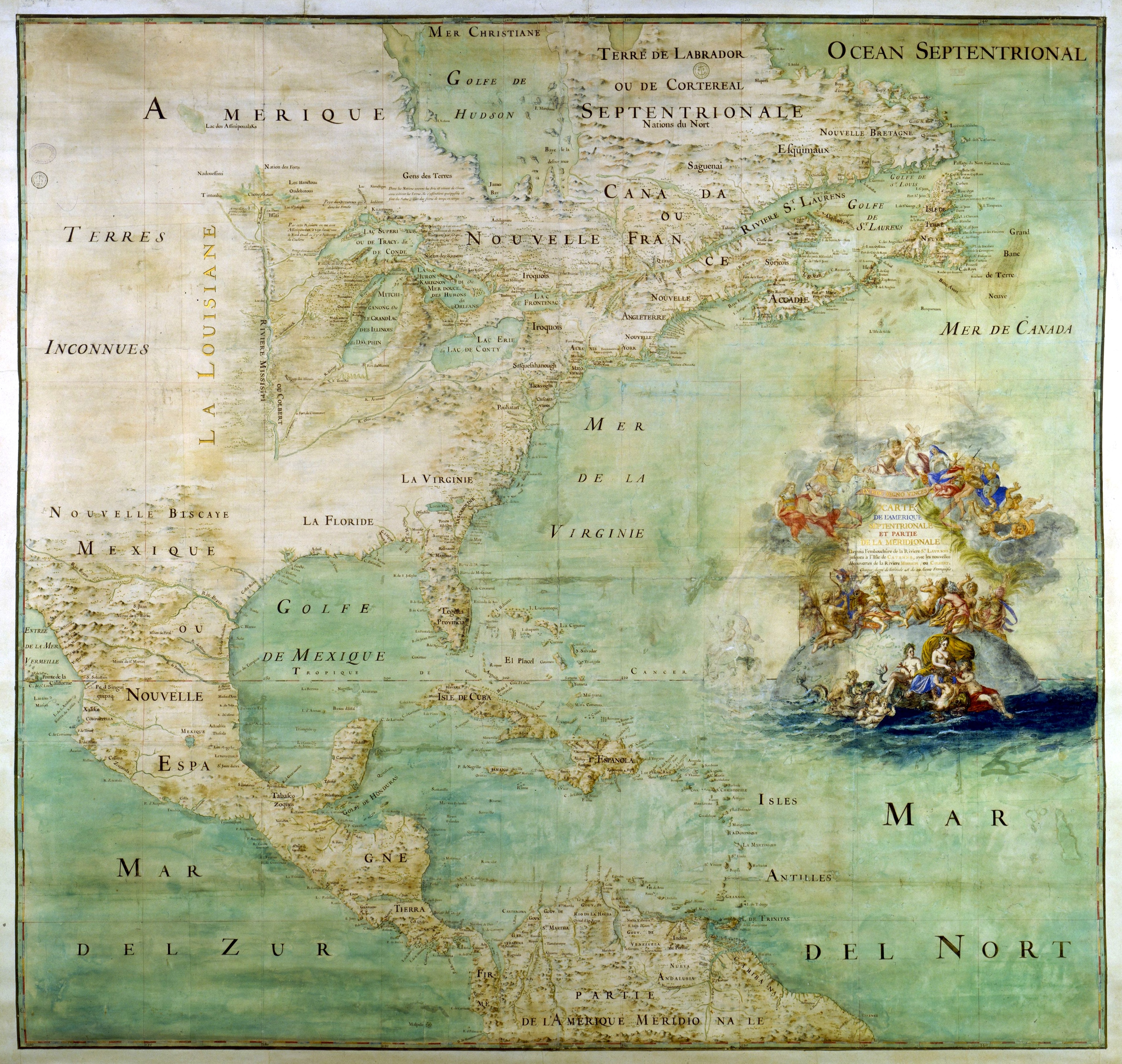
English: Map of the northern part and parts of the southern parts of the America, from the mouth of the Saint Laurent River to the Island of Cayenne,with the new discoveries of the Mississipi (or Colbert) River. This map shows the results of the expeditions of Father Marquette and L. Jolliet (1673) and the Cavelier de la Salle expedition in the Mississipi valley. The map shows three forts built between 1679 and 1680: Conty fort (near Niagara Falls), Miamis Fort (south of Michigan lake), and Crèvecœur fort (Left bank of the Illinois River). Mississippi river course is only shown upstream of Ohio confluence.
Français : Carte de l'Amérique septentrionale et partie de la méridionale depuis l'embouchure de la rivière St Laurens jusqu'à l'isle de Cayenne avec les nouvelles découvertes de la rivière de Mississipi ou Colbert [attribuée à l'abbé Bernou]. Montre le résultat des expéditions du is (au sud du Lac Michigan), fort Crèvecœur (rive gauche de l'Illinois). Le cours du Mississippi n'est figuré que jusqu'à sa confluence avec l'Ohio. Collation : 1 carte, ms. col. , 163 × 147 cm
Čeština: Mapa severní části a částí jižních částí Ameriky, od ústí řeky Saint Laurent po ostrov Cayenne, s novými objevy řeky Mississipi (neboli Colbert). Tato mapa ukazuje výsledky expedic otce Marquette a L. Jolliet (1673) a expedice Cavelier de la Salle v údolí Mississipi. Mapa ukazuje tři pevnosti postavené v letech 1679 až 1680: pevnost Conty (poblíž Niagarských vodopádů), pevnost Miamis (jižně od Michiganského jezera) a pevnost Crèvecœur (levý břeh řeky Illinois). Kurz řeky Mississippi je zobrazen pouze před soutokem s řekou Ohio. |
| 日期 | 約1681年 |
| 來源 | Uploaded by David.Monniaux |
| 創作作者 |
Bernou, Claude (b. 16..–d. 17..), Abbot |
| 地理參考 | 如果不合適,請設定「warp_status = skip」為隱藏。 |
This image was selected as picture of the day on Wikimedia Commons for 22 March 2006. It was captioned as follows: English: Early map of North America Other languages:
Alemannisch: Alti Kart vun Nordamerika Čeština: Mapa Severní Ameriky ze 17. století. Deutsch: Frühe Karte von Nordamerika English: Early map of North America Español: Antiguo mapa de América del Norte Français : Ancienne carte de l'Amérique du nord Galego: mapa de America do Norte Italiano: Antica mappa dell'America del Nord Lëtzebuergesch: Historesch Kaart vun Nordamerika. Magyar: Észak-Amerika XVII. századi térképe Norsk nynorsk: Tidleg kart over Nord-Amerika. Polski: Siedemnastowieczna mapa Ameryki Północnej Português: Mapa antigo da América do Norte Suomi: Vanha Pohjois-Amerikan kartta. Български: Ранна карта на Северна Америка (17 век) Русский: Древняя карта Северной Америки 日本語: 初期の北アメリカの地図 中文: 北美17世纪时的地图。 |
授權條款
本影像屬於公有領域,因為該影像是單純針對一件公有領域原作進行機械掃描,或(從現有證據來看)類似掃描而來的,或該重製照片可以預期不會有版權保護。原作屬於公有領域,是因下述原因:
本標籤主要用於該掃描件有可能使用任何增強功能(如亮度、對比度、色彩調整、銳利化等),而這些增強功能無法達到原創性而無法產生版權的情形下使用。而該標籤也能使用在無法判定本掃描件使用任何增強功能,以及已知使用增強功能但沒有充分證據時。對於採取原始忠實掃描而不使用增強功能的照片,可以適當採用{{PD-old}}標籤取代。對於本標籤的使用方法,參見如何使用PD-Scan標籤。  | ||||
檔案歷史
點選日期/時間以檢視該時間的檔案版本。
| 日期/時間 | 縮圖 | 尺寸 | 用戶 | 備註 | |
|---|---|---|---|---|---|
| 目前 | 2012年6月29日 (五) 14:13 | | 3,841 × 3,641(5.86 MB) | Paris 16 | cropped |
| 2005年5月15日 (日) 20:12 |  | 3,946 × 3,697(6.2 MB) | David.Monniaux | ||
| 2005年5月15日 (日) 18:23 |  | 3,792 × 3,576(5.89 MB) | David.Monniaux | {{Français}} '''Auteur :''' Bernou, Claude (16..-17..?), abbé '''Titre :''' ''Carte de l'Amérique septentrionale et partie de la méridionale depuis l'embouchure de la rivière St Laurens jusqu'à l'isle de Cayenne avec les nouvelles décou |
檔案用途
下列頁面有用到此檔案:
全域檔案使用狀況
以下其他 wiki 使用了這個檔案:
- af.wikipedia.org 的使用狀況
- ar.wikipedia.org 的使用狀況
- azb.wikipedia.org 的使用狀況
- az.wikipedia.org 的使用狀況
- br.wikipedia.org 的使用狀況
- ca.wikipedia.org 的使用狀況
- cs.wikipedia.org 的使用狀況
- de.wikipedia.org 的使用狀況
- en.wikipedia.org 的使用狀況
- New France
- Médard des Groseilliers
- Illinois Country
- Louisiana (New France)
- Spanish Texas
- Timeline of the European colonization of North America
- User:Cliché Online/New France
- French colonization of Texas
- Portal:Maps/Maps/Historical
- Portal:Maps/Maps/Historical/12
- Fort Crevecoeur
- List of French possessions and colonies
- Cartography of the United States
- Timeline of European imperialism
- Wikipedia:Featured picture candidates/Bernou's map of Nothern America
- Wikipedia:Featured picture candidates/March-2017
- Portal:Maps
- Fort Saint-Louis (Texas)
- User:Falcaorib/Canada, United States and Mexico
- eo.wikipedia.org 的使用狀況
- es.wikipedia.org 的使用狀況
檢視此檔案的更多全域使用狀況。