
File:Europe sunshine hours map.png

預覽大小:655 × 600 像素。 其他解析度:262 × 240 像素 | 524 × 480 像素 | 839 × 768 像素 | 1,119 × 1,024 像素 | 1,360 × 1,245 像素。
原始檔案 (1,360 × 1,245 像素,檔案大小:97 KB,MIME 類型:image/png)
摘要
| 描述 |
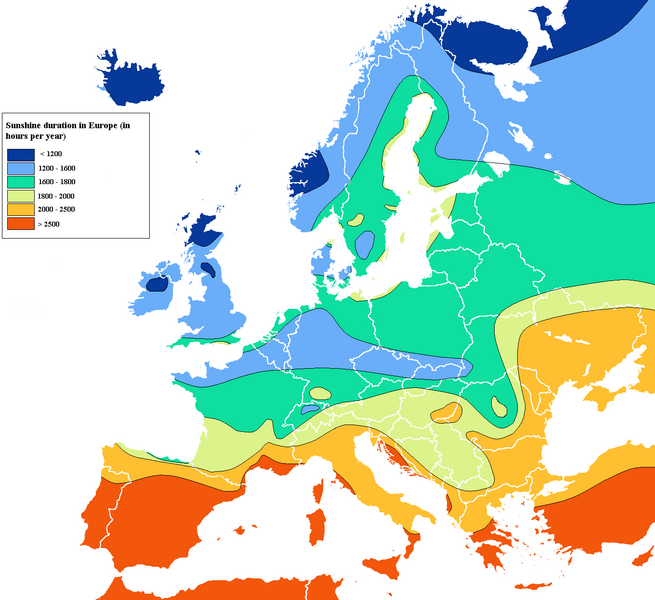
English: Simplified map of sunshine duration in Europe according to national data |
| 日期 | 12/11/2010 |
| 來源 | 自己的作品 |
| 作者 | XL3 |
授權條款
我,本作品的著作權持有者,決定用以下授權條款發佈本作品:
此檔案採用創用CC 姓名標示-相同方式分享 3.0 未在地化版本授權條款。
- 您可以自由:
- 分享 – 複製、發佈和傳播本作品
- 重新修改 – 創作演繹作品
- 惟需遵照下列條件:
- 姓名標示 – 您必須指名出正確的製作者,和提供授權條款的連結,以及表示是否有對內容上做出變更。您可以用任何合理的方式來行動,但不得以任何方式表明授權條款是對您許可或是由您所使用。
- 相同方式分享 – 如果您利用本素材進行再混合、轉換或創作,您必須基於如同原先的相同或兼容的條款,來分布您的貢獻成品。

|
已授權您依據自由軟體基金會發行的無固定段落、封面文字和封底文字GNU自由文件授權條款1.2版或任意後續版本,對本檔進行複製、傳播和/或修改。該協議的副本列在GNU自由文件授權條款中。 |
您可以選擇您需要的授權條款。
檔案歷史
點選日期/時間以檢視該時間的檔案版本。
| 日期/時間 | 縮圖 | 尺寸 | 使用者 | 備註 | |
|---|---|---|---|---|---|
| 目前 | 2023年10月24日 (二) 01:13 | | 1,360 × 1,245(97 KB) | Uness232 | Reverted to version as of 07:25, 25 February 2023 (UTC): Unfortunately still wrong. I appreciate the attempts, but most of the Black Sea is below 2000 hours, which is just not that easy to fix. |
| 2023年8月14日 (一) 16:40 |  | 1,360 × 1,175(774 KB) | Iktsokh | Tried to be as accurate as possible based on your data (I sincerely appreciate your clarifications and corrections, it's important). | |
| 2023年2月25日 (六) 07:25 |  | 1,360 × 1,245(97 KB) | Uness232 | Reverted to version as of 20:37, 20 February 2023 (UTC) Again, I am not happy that I'm reverting this, but the information is still quite wrong. There is a somewhat extensive region (more extensive than the region in Spain anyway) or northern Turkey that should be around 1400-1600. If the Turkish official site is tough to navigate, use the links in the Wikipedia pages Trabzon, Rize, Giresun and Ordu. | |
| 2023年2月21日 (二) 14:21 |  | 1,360 × 1,175(774 KB) | Iktsokh | Correction | |
| 2023年2月20日 (一) 20:37 |  | 1,360 × 1,245(97 KB) | Uness232 | Reverted to version as of 17:07, 6 December 2010 (UTC) I would not want to revert, but the data of (north)eastern Turkey is laughably wrong. | |
| 2022年9月16日 (五) 10:39 |  | 1,360 × 1,175(914 KB) | Рагин1987 | Extended map | |
| 2010年12月6日 (一) 17:07 |  | 1,360 × 1,245(97 KB) | XL3 | Norway and Northwest Russia : more accurate according to national data | |
| 2010年12月4日 (六) 16:06 |  | 1,360 × 1,245(98 KB) | XL3 | Inconsistent and contradictory data between swedish ones (near Denmark) and danish one. Kept danish one for Denmark... | |
| 2010年11月27日 (六) 16:36 |  | 1,360 × 1,245(98 KB) | XL3 | Ukraine, Southern Belarus and Moldavia : more accurate + other minor edits | |
| 2010年11月25日 (四) 14:16 |  | 1,360 × 1,245(98 KB) | XL3 | Mistake and esthetics |
檔案用途
全域檔案使用狀況
以下其他 wiki 使用了這個檔案:
- da.wikipedia.org 的使用狀況
- en.wikipedia.org 的使用狀況
- en.wikivoyage.org 的使用狀況
- es.wikibooks.org 的使用狀況
- fr.wikipedia.org 的使用狀況
- hu.wikipedia.org 的使用狀況
- ilo.wikipedia.org 的使用狀況
- incubator.wikimedia.org 的使用狀況
- ko.wikipedia.org 的使用狀況
- nds.wikipedia.org 的使用狀況
- nl.wikibooks.org 的使用狀況
- no.wikipedia.org 的使用狀況
- pl.wikipedia.org 的使用狀況
- pt.wikipedia.org 的使用狀況