
File:Chunqiu map-zh-classical.png
無更高解析度可提供。
Chunqiu_map-zh-classical.png (430 × 550 像素,檔案大小:273 KB,MIME 類型:image/png)

|
This map has been uploaded by Electionworld from en.wikipedia.org to enable the |
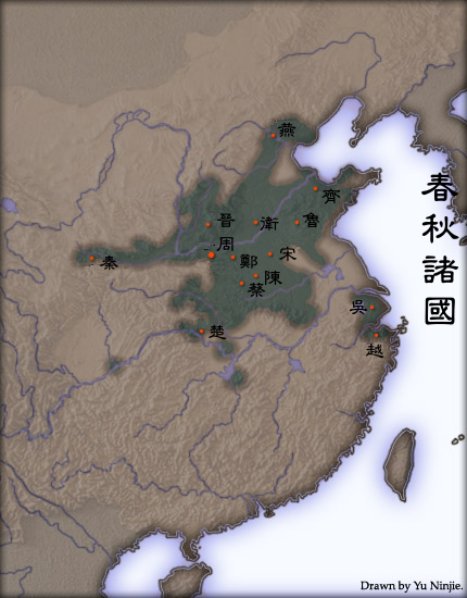
Extent of urbanisation in Spring and Autumn Period China. Based on "The spread of cities in China during the Spring and Autumns period" in Cultural Atlas of China. The first capital city of selected states are marked.
Created and copyright (2004) by Yu Ninjie. Released under the GNU FDL.
The originally picture is located at Image:Chunqiu map.jpg.
The Classical Chinese Modification is made by User:Itsmine.

|
已授權您依據自由軟體基金會發行的無固定段落、封面文字和封底文字GNU自由文件授權條款1.2版或任意後續版本,對本檔進行複製、傳播和/或修改。該協議的副本列在GNU自由文件授權條款中。 |
| 此檔案採用創用CC 姓名標示-相同方式分享 3.0 未在地化版本授權條款。 | ||
| 姓名標示: Yeu Ninje | ||
| ||
| 已新增授權條款標題至此檔案,作為GFDL授權更新的一部份。 |
檔案歷史
點選日期/時間以檢視該時間的檔案版本。
| 日期/時間 | 縮圖 | 尺寸 | 使用者 | 備註 | |
|---|---|---|---|---|---|
| 目前 | 2007年4月16日 (一) 07:35 | | 430 × 550(273 KB) | Itsmine | {{ew|en|Yeu Ninje}} Extent of {{link|urbanisation}} in {{link|Spring and Autumn Period}} China. Based on "The spread of cities in China during the Spring and Autumns period" in ''Cultural Atlas of China''. The first capital city of selected states are mar |
檔案用途
下列87個頁面有用到此檔案:
- 周朝
- User:Aquacryst
- User:B0924
- User:BigKai/用户框
- User:C1920
- User:Chakhar
- User:Choipo
- User:Cloudwat
- User:Cqlwx
- User:Dbslikacheung/用戶框
- User:Dnssgh/用户框
- User:Dora168
- User:Duzhe
- User:Edwardtp/info
- User:Feliciachian
- User:G9351010
- User:Goodj111
- User:Guozesheng
- User:Gzhao
- User:HB~zhwiki/我的用戶框
- User:Hankensai
- User:Happy Kevin/template
- User:Huaxiawangguo
- User:Huhaoyu321
- User:Jason22/info
- User:Jpoon
- User:Jungleford
- User:Keasung
- User:Lawrence1998
- User:Life Stream
- User:Nameless·Scorpio
- User:Nihilism nameless
- User:Oreox100
- User:Pino100
- User:Pkou
- User:Polar1/info
- User:Reverland
- User:Rex Carolus/吴地统治者列表
- User:Richin39
- User:Sengnam
- User:Shaogan0117
- User:Show04191
- User:Starfirewind
- User:Tonyshew
- User:Unphoenix
- User:Vector wang
- User:Vphoenix
- User:WU Zhitong
- User:Wangziyu9
- User:Wirkwitz
- User:Yannuk
- User:Yew
- User:Zinc Leng/About Me
- User:云不会哭/box
- User:允乔
- User:冉雲
- User:凱子書生
- User:创新基金
- User:右衛守
- User:周子仪
- User:周子仪/main
- User:夜空中的男孩
- User:天涼/駱雋灝的子頁面
- User:姒姓賢寧/用户框(下)
- User:悅學越難
- User:昏君/帝 國
- User:星乂夜月
- User:星光下的人
- User:木易天易
- User:梦回大唐
- User:源帅元美
- User:熙熙攘攘熙熙
- User:玖巧仔/旧版用户页
- User:空间的拓荒者/兴趣爱好
- User:立足东方
- User:維利
- User:肆意醉飲思緒清/我的用戶框
- User:衖追命/巴別
- User:願聞其祥
- User:高新技术
- User:鸟枪换炮
- User:黑色騎士團員
- User talk:Sinji
- User talk:SunAfterRain/存檔/2018
- Wikipedia:用户框/历史
- Template:User 春秋
- Template talk:Babel-N
全域檔案使用狀況
以下其他 wiki 使用了這個檔案: