
File:2011 Syria protests.svg

此 SVG 檔案的 PNG 預覽的大小:725 × 599 像素。 其他解析度:290 × 240 像素 | 581 × 480 像素 | 929 × 768 像素 | 1,239 × 1,024 像素 | 2,478 × 2,048 像素 | 922 × 762 像素。
原始檔案 (SVG 檔案,表面大小:922 × 762 像素,檔案大小:287 KB)
W3C-validity not checked.
摘要
| 描述 |
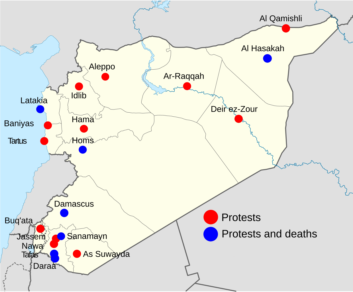
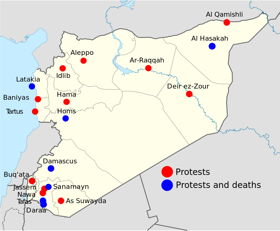
Note: This is an OUTDATED map that stopped being updated since 15 April 2011, protests and deaths has since then occurred in more towns, city's and villages, so this map shouldn't be used at any article. Deutsch: Statuskarte der syrischen Aufstände 2011 English: 2011 Syria protests status map. Français : Carte montrant le status des manifestations en Syrie 2011 Português: Mapa mostrando a situação dos protestos na Síria em 2011 Map is equirectangular projection, N/S stretching 115 %. Geographic limits of the map: * N: 37.6° N * S: 32.0° N * W: 34.9° E * E: 42.7° E |
| 日期 | (UTC) |
| 來源 | |
| 作者 |
|
| 其他版本 |
此檔案衍生的作品: |
| 這是一張修飾過的圖片,即本圖片是用軟體修改過後的版本,修改的方式或內容有:Made it into a map for 2011 Syrian protests。原版圖片來源:Syria location map.svg。修改者:Supreme Deliciousness。
|
我,本作品的著作權持有者,決定用以下授權條款發佈本作品:
此檔案採用創用CC 姓名標示-相同方式分享 3.0 未在地化版本授權條款。
- 您可以自由:
- 分享 – 複製、發佈和傳播本作品
- 重新修改 – 創作演繹作品
- 惟需遵照下列條件:
- 姓名標示 – 您必須指名出正確的製作者,和提供授權條款的連結,以及表示是否有對內容上做出變更。您可以用任何合理的方式來行動,但不得以任何方式表明授權條款是對您許可或是由您所使用。
- 相同方式分享 – 如果您利用本素材進行再混合、轉換或創作,您必須基於如同原先的相同或兼容的條款,來分布您的貢獻成品。

|
已授權您依據自由軟體基金會發行的無固定段落、封面文字和封底文字GNU自由文件授權條款1.2版或任意後續版本,對本檔進行複製、傳播和/或修改。該協議的副本列在GNU自由文件授權條款中。 |
您可以選擇您需要的授權條款。
原始上傳日誌
This image is a derivative work of the following images:
- File:Syria_location_map.svg licensed with Cc-by-sa-3.0, GFDL
- 2010-09-30T19:34:14Z NordNordWest 922x762 (250221 Bytes) Reverted to version as of 08:25, 29 September 2010: NO CHANGES WITHOUT DISCUSSION
- 2010-09-30T19:08:16Z Supreme Deliciousness 1000x827 (246114 Bytes) All sources on talkpage show with the same color
- 2010-09-29T08:25:21Z NordNordWest 922x762 (250221 Bytes) Reverted to version as of 18:29, 29 November 2008: no changes without discussion
- 2010-09-29T00:36:20Z Supreme Deliciousness 1000x827 (246114 Bytes) Reverted to version as of 18:38, 22 August 2008
- 2008-11-29T18:29:45Z NordNordWest 922x762 (250221 Bytes) '
- 2008-08-22T18:38:21Z NordNordWest 1000x827 (246114 Bytes) {{Information |Description= {{de|Positionskarte von [[:de:Syrien|Syrien]]}} Quadratische Plattkarte, N-S-Streckung 115 %. Geographische Begrenzung der Karte: * N: 37.6° N * S: 32.0° N * W: 34.9° O * O: 42.7° O {{en|Locati
Uploaded with derivativeFX
檔案歷史
點選日期/時間以檢視該時間的檔案版本。
| 日期/時間 | 縮圖 | 尺寸 | 使用者 | 備註 | |
|---|---|---|---|---|---|
| 目前 | 2011年11月12日 (六) 18:55 | | 922 × 762(287 KB) | Fred the Oyster | Optimise, change font to the more universal Arial |
| 2011年4月15日 (五) 09:48 |  | 922 × 762(424 KB) | Supreme Deliciousness | 14 April + As Suwayda | |
| 2011年4月9日 (六) 10:12 |  | 922 × 762(422 KB) | Supreme Deliciousness | April 8, + Tartus, Edlib | |
| 2011年4月2日 (六) 13:19 |  | 922 × 762(420 KB) | Supreme Deliciousness | Update April 1-2 Damascus death and Buq'ata. Sorry NikNaks93, cant edit your file, have to use mine. | |
| 2011年4月2日 (六) 11:38 |  | 600 × 496(598 KB) | FunkMonk | My mistake. | |
| 2011年4月2日 (六) 10:29 |  | 600 × 496(598 KB) | NikNaks | One last try with text as paths | |
| 2011年4月2日 (六) 10:27 |  | 600 × 496(481 KB) | NikNaks | Try again. | |
| 2011年4月2日 (六) 10:26 |  | 300 × 248(493 KB) | NikNaks | A little cleanup and normalisation to try to fix the text rendering | |
| 2011年3月26日 (六) 18:50 |  | 922 × 762(419 KB) | Supreme Deliciousness | Tafas | |
| 2011年3月26日 (六) 00:10 |  | 922 × 762(419 KB) | Supreme Deliciousness | Update, 25 March, Sanamayn, Homs, Latakia |
檔案用途
下列頁面有用到此檔案:
全域檔案使用狀況
以下其他 wiki 使用了這個檔案:
- ca.wikinews.org 的使用狀況
- en.wikipedia.org 的使用狀況
- fi.wikipedia.org 的使用狀況
- hu.wikipedia.org 的使用狀況
- it.wikipedia.org 的使用狀況
- sh.wikipedia.org 的使用狀況
- ta.wikipedia.org 的使用狀況