
File:US pennsylvanian general USGS.jpg

此为最大尺寸。
US_pennsylvanian_general_USGS.jpg (500 × 353像素,文件大小:22 KB,MIME类型:image/jpeg)

|
此map图片可使用矢量图形重新创建为SVG文件。这具有很多好处;更多信息请参见共享资源:待清理媒体。如果存在此图片的SVG格式,请将其上传,然后将此模板替换为
{{vector version available|新图片名称}}。
建议您将SVG命名为“US pennsylvanian general USGS.svg”,这样在使用Vector version available(或Vva)模板时就不需要填写新图片名称参数。 |


摘要
| 描述 |
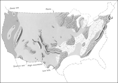
English: Generalized geographic map of the United States location in Middle Pennsylvanian time.
During the Carboniferous period, the contrast in the distribution of land and water from the ancient past to the present becomes more dramatic. The map shows the outline of the United States as it looked during the Pennsylvanian Period some 300 million years ago. It gives the appearance of reversing present-day geography. A highland which lay to the east, south, and north supplied much of the sedimentary debris that was spread over the midwestern part of the United States. The Midwest was mainly a low swampy area in which scouring rushes and fern trees grew in profusion. Sediment was carried into the region from deltas to the east. From time to time, the level of the sea fluctuated -- possibly because of glacial conditions in the Southern Hemisphere. Swamps were flooded, and forests were destroyed. Slowly, layers rich in tree stumps, spores, branches, and leaves were deposited. Later, heat and pressure changed these layers into the coal beds that are so extensive in Illinois, Kentucky, Pennsylvania, West Virginia, and Tennessee. To the west, marine limestones, sandstones, and shales accumulated in shallow seas whose vast expanses were dotted with shoals and islands. Some of the very large islands were formed by the buckling and uplifting of parts of the Earth's crust. |
| 日期 | 2001年前后 |
| 来源 | http://pubs.usgs.gov/gip/continents/pennmap.jpg |
| 作者 |
许可协议
|
|
原始上传日志
原始描述頁面位於這裡。下列使用者名稱均來自en.wikipedia。
| 日期/时间 | 大小 | 用户 | 备注 |
|---|---|---|---|
| 2005-04-15 02:48 | 500×353× (22509 bytes) | SEWilco | Generalized geographic map of the [[United States]] in [[Middle Pennsylvanian]] time. In the Coal Age, the contrast in the distribution of land and water from the ancient past to the present becomes more dramatic. The map shows the outline of the United |
原始描述頁面位於這裡。下列使用者名稱均來自el.wikipedia。
| 日期/时间 | 大小 | 用户 | 备注 |
|---|---|---|---|
| 2016-01-16 16:00 | 500×353× (22509 bytes) | Kalogeropoulos | {{Πληροφορίες εικόνας |Περιγραφή=Γενικός γεωγραφικός χάρτης των [[ΗΠΑ]] κατά τη μέση [[Πενσυλβάνια εποχή]] |Πηγή=http://pubs.usgs.gov/gip/continents/pennmap.jpg |Η... |
文件历史
点击某个日期/时间查看对应时刻的文件。
| 日期/时间 | 缩略图 | 大小 | 用户 | 备注 | |
|---|---|---|---|---|---|
| 当前 | 2016年10月22日 (六) 07:04 | | 500 × 353(22 KB) | MARKELLOS | Transferred from el.wikipedia |
文件用途
以下页面使用本文件:
全域文件用途
以下其他wiki使用此文件:
- el.wikipedia.org上的用途
- en.wikipedia.org上的用途
- fa.wikipedia.org上的用途