
File:Taklimakanm.jpg

本预览的尺寸:800 × 600像素。 其他分辨率:320 × 240像素 | 640 × 480像素 | 1,024 × 768像素 | 1,280 × 960像素 | 2,560 × 1,920像素 | 4,800 × 3,600像素。
原始文件 (4,800 × 3,600像素,文件大小:2.79 MB,MIME类型:image/jpeg)
摘要
| 描述 |
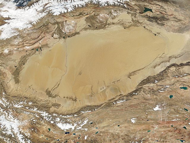
English: The Taklamakan Desert in northwest China is a vast region of sand desert sitting in a depression between two high, rugged mountain ranges. Seen in this true-color MODIS image from October 27, 2001, the Taklimakan's rolling sand dunes stretch out over several hundred thousand square miles in the Xinjiang region of China. The desert is hemmed in to the north by the snow-covered Tien Shan Mountain range and to the south by the rugged Kunlun Mountains. At the lower left corner of the image is the Karakoram Mountain range, where the world's second highest mountain, K2, casts a blue shadow (see high-resolution image for an up-close look). Desertification and shifting sand dunes are a major concern for the farmers and herders who live at the Taklimakan's edge. At the bottom of the image lies the Tibetan Plateau. |
| 日期 | 摄于2001年10月27日 |
| 来源 | http://www.gsfc.nasa.gov/indepth/photos_earth2001_p1.html (archive) |
| 作者 | NASA/GSFC/MODIS Team |
许可协议
| 本文件完全由NASA创作,在美国属于公有领域。根据NASA的版权方针,NASA的材料除非另有声明否则不受版权保护。(参见Template:PD-USGov/zh、NASA版权方针页面或JPL图片使用方针。) | ||
 |
警告:
|
文件历史
点击某个日期/时间查看对应时刻的文件。
| 日期/时间 | 缩略图 | 大小 | 用户 | 备注 | |
|---|---|---|---|---|---|
| 当前 | 2020年9月27日 (日) 02:05 | | 4,800 × 3,600(2.79 MB) | Huntster | 250m resolution version. |
| 2005年8月23日 (二) 21:33 |  | 1,200 × 900(324 KB) | Nanosmile | Description: The Taklimakan Desert in northwest China is a vast region of sand desert sitting in a depression between two high, rugged mountain ranges. Seen in this true-color MODIS image from October 27, 2001, the Taklimakan's rolling sand dunes stretch |
文件用途
以下页面使用本文件:
全域文件用途
以下其他wiki使用此文件:
- af.wikipedia.org上的用途
- als.wikipedia.org上的用途
- bn.wikipedia.org上的用途
- br.wikipedia.org上的用途
- ca.wikipedia.org上的用途
- de.wikipedia.org上的用途
- en.wikipedia.org上的用途
- eo.wikipedia.org上的用途
- es.wikipedia.org上的用途
- et.wikipedia.org上的用途
- eu.wikipedia.org上的用途
- fa.wikipedia.org上的用途
- fi.wikipedia.org上的用途
- fr.wikipedia.org上的用途
- gl.wikipedia.org上的用途
- he.wikipedia.org上的用途
- hu.wikipedia.org上的用途
- hy.wikipedia.org上的用途
- id.wikipedia.org上的用途
- it.wikipedia.org上的用途
- ku.wikipedia.org上的用途
- ky.wikipedia.org上的用途
- nds.wikipedia.org上的用途
- nn.wikipedia.org上的用途
- no.wikipedia.org上的用途
- pt.wikipedia.org上的用途
- ro.wikipedia.org上的用途
- ru.wikipedia.org上的用途
- sr.wikipedia.org上的用途
- th.wikipedia.org上的用途
查看本文件的更多全域用途。