
File:Pamir Highway Route.jpg

本预览的尺寸:592 × 600像素。 其他分辨率:237 × 240像素 | 474 × 480像素 | 758 × 768像素 | 1,052 × 1,066像素。
原始文件 (1,052 × 1,066像素,文件大小:200 KB,MIME类型:image/jpeg)
| 描述 |
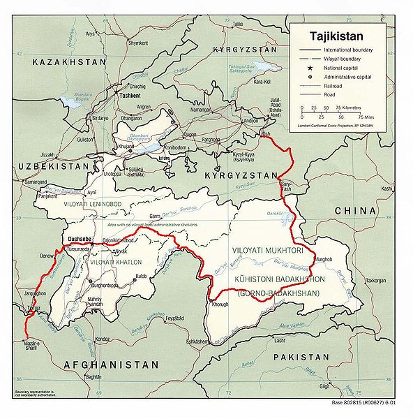
English: Map showing the route of the Pamir Highway through Afghanistan, Uzbekistan, Tajikistan, and Kyrgyzstan. |
| 日期 | |
| 来源 |
http://www.lib.utexas.edu/maps/tajikistan.html
|
| 作者 | Derived from CIA map by Bantman at en.wikipedia, transferred to Commons by User:Man77 using CommonsHelper. |
| 授权 (二次使用本文件) |
PD-USGOV; PD-AUTHOR. |
许可协议
此作品在美国属于公有领域,因为其是由美国政府的官员或雇员,基于其个人公务目的制作的作品,参考美国法典第17篇第1章第105条。
注意︰本模板仅适用于美国联邦政府的原创作品,不适用于任何美国州、属地、联邦个体、县、市或任何次级政府的作品。本模板也不适用于1978年以后由美国邮政署出版的邮票图案(参看美国版权局实践纲领第313.6(C)(1)条)。也不适用于部分美国硬币;参看美国铸币局使用条款。 |
 | |
| 本文件已被确认为免除已知的著作权法限制(包括所有相关权利)。 | ||
| 本作品已被作者Bantman释出到公有领域。这适用于全世界。 在一些国家这可能不合法;如果是这样的话,那么: Bantman无条件地授予任何人以任何目的使用本作品的权利,除非这些条件是法律规定所必需的。
|
原始上传日志
原始描述頁面位於這裡。下列使用者名稱均來自en.wikipedia。
- 2005-08-30 22:02 Bantman 1052×1066× (204866 bytes) Map showing the route of the Pamir Highway through Afghanistan, Tajikistan, and Kyrgyzstan. Derived by me from a CIA map located at the [[University_of_Texas_at_Austin#Facilities|Perry-Castañeda Library (PCL) of the University of Tex
文件历史
点击某个日期/时间查看对应时刻的文件。
| 日期/时间 | 缩略图 | 大小 | 用户 | 备注 | |
|---|---|---|---|---|---|
| 当前 | 2009年4月11日 (六) 13:36 | | 1,052 × 1,066(200 KB) | File Upload Bot (Magnus Manske) | {{BotMoveToCommons|en.wikipedia|year={{subst:CURRENTYEAR}}|month={{subst:CURRENTMONTHNAME}}|day={{subst:CURRENTDAY}}}} {{Information |Description={{en|Map showing the route of the en:Pamir Highway through en:Afghanistan, en:Tajikistan, |
文件用途
以下3个页面使用本文件:
全域文件用途
以下其他wiki使用此文件:
- ca.wikipedia.org上的用途
- cs.wikipedia.org上的用途
- de.wikipedia.org上的用途
- en.wikipedia.org上的用途
- es.wikipedia.org上的用途
- fa.wikipedia.org上的用途
- fr.wikipedia.org上的用途
- hu.wikipedia.org上的用途
- it.wikipedia.org上的用途
- ja.wikipedia.org上的用途
- ko.wikipedia.org上的用途
- lt.wikipedia.org上的用途
- lv.wikipedia.org上的用途
- nl.wikipedia.org上的用途
- pt.wikipedia.org上的用途
- ru.wikipedia.org上的用途
- sl.wikipedia.org上的用途
- sv.wikipedia.org上的用途
- uk.wikipedia.org上的用途
- www.wikidata.org上的用途