
File:Nasa satellite photo side by side 2007-10-22.jpg
原始文件 (1,050 × 410像素,文件大小:75 KB,MIME类型:image/jpeg)
摘要
| 描述 |
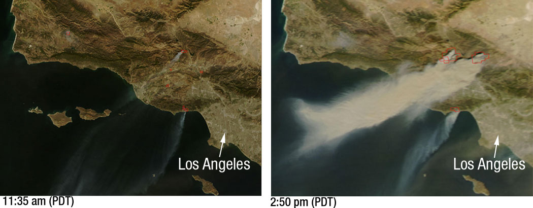
Powerful Santa Ana winds have fueled more than 10 large wildfires throughout Southern California, stretching from Santa Barbara to San Diego. This pair of images, depicting the area around Los Angeles on October 21, 2007, shows just how quickly the fires grew. The left image, captured by NASA’s Terra satellite at 11:35 a.m. local time, shows several fires giving off small plumes of smoke. Just over 3 hours later, at 2:50 p.m. when NASA’s Aqua satellite passed overhead, large amounts of smoke were pouring from blazes northwest of Los Angeles. Actively burning fires are outlined in red. In the right image plumes of smoke can be seen blowing off the coast, indicating the intensity of the winds and the presence of additional fires farther south. According to the National Interagency Fire Center, these blazes have burned over 84,000 acres since they began over the weekend. Thousands of residents have been evacuated from their homes and a state of emergency has been issued for 7 California counties. |
| 日期 | |
| 来源 | Nasa |
| 作者 | NASA/MODIS Rapid Response. Story credit: Laura Spector, NASA Goddard Space Flight Center. |
许可协议
| 本文件完全由NASA创作,在美国属于公有领域。根据NASA的版权方针,NASA的材料除非另有声明否则不受版权保护。(参见Template:PD-USGov/zh、NASA版权方针页面或JPL图片使用方针。) | ||
 |
警告:
|
文件历史
点击某个日期/时间查看对应时刻的文件。
| 日期/时间 | 缩略图 | 大小 | 用户 | 备注 | |
|---|---|---|---|---|---|
| 当前 | 2007年10月23日 (二) 21:29 | 1,050 × 410(75 KB) | Tom | higher res | |
| 2007年10月23日 (二) 03:51 | 520 × 203(24 KB) | Johntex~commonswiki | {{Information |Description=Powerful Santa Ana winds have fueled more than 10 large wildfires throughout Southern California, stretching from Santa Barbara to San Diego. This pair of images, depicting the area around Los Angeles on October 21, 2007, shows |
文件用途
以下页面使用本文件:
全域文件用途
以下其他wiki使用此文件:
- ar.wikipedia.org上的用途
- de.wikipedia.org上的用途
- en.wikipedia.org上的用途
- en.wikinews.org上的用途
- es.wikinews.org上的用途
- pl.wikinews.org上的用途
- simple.wikipedia.org上的用途
- sv.wikipedia.org上的用途