File:Hurricane Paul TRMM Image (2006).jpg

页面内容不支持其他语言。
這個文件來自維基共享資源
维基百科,自由的百科全书

原始文件(1,024 × 1,024像素,文件大小:479 KB,MIME类型:image/jpeg


摘要

描述

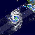
Hurricane Paul, the 10th hurricane of the season in the East Pacific, began as a tropical depression (area of unusually low air pressure at the ocean surface) during the early morning hours of October 21, 2006 (local time), about 265 miles south-southwest of Manzanillo, Mexico. Paul reached hurricane intensity on the afternoon (local time) of October 22.

The Tropical Rainfall Measuring Mission (TRMM) satellite captured this image of Paul at 5:15 p.m. Pacific Daylight Time on October 22 (00:15 UTC, October 23), as the storm was transitioning from a tropical storm into a hurricane. The image is a top-down view of where the heaviest rain was occurring. Rain rates in the center of the swath come from the TRMM Precipitation Radar, while those in the outer swath are from the TRMM Microwave Imager. These rain rates are overlaid on infrared data from the TRMM Visible Infrared Scanner.

A small eye is visible near the center of the storm, with several moderate-intensity bands of rain (green arcs) spiraling inward from the south. These rainbands are the tell-tale signs of a developed circulation. Scattered areas of heavy rain (shown in red) are also evident, including one in the storm’s eyewall (central ring of clouds) just to the east of the center. At the time of this image, the National Hurricane Center (NHC) estimated Paul had sustained winds of 55 knots (63 miles per hour). Paul became a hurricane just a few hours later.

From its low-earth orbit, TRMM has been providing valuable images and information on tropical cyclones around the Tropics since 1997, especially over open ocean where direct observations are limited. TRMM is a joint mission between NASA and the Japanese space agency, JAXA.
日期
来源 http://earthobservatory.nasa.gov/NaturalHazards/natural_hazards_v2.php3?img_id=13940
作者 NASA images by Hal Pierce (SSAI/NASA GSFC), and caption by Steve Lang (SSAI/NASA GSFC).
授权
(二次使用本文件)
Public domain 本文件完全由NASA创作,在美国属于公有领域。根据NASA的版权方针,NASA的材料除非另有声明否则不受版权保护。(参见Template:PD-USGov/zhNASA版权方针页面JPL图片使用方针。)
警告:

说明

添加一行文字以描述该文件所表现的内容

此文件中描述的项目

描繪內容

image/jpeg

文件历史

点击某个日期/时间查看对应时刻的文件。

日期/时间缩⁠略⁠图大小用户备注
当前2006年10月27日 (五) 03:122006年10月27日 (五) 03:12版本的缩略图1,024 × 1,024(479 KB)A7xHurricane Paul, the 10th hurricane of the season in the East Pacific, began as a tropical depression (area of unusually low air pressure at the ocean surface) during the early morning hours of October 21, 2006 (local time), about 265 miles south-southwest

以下页面使用本文件:

全域文件用途

以下其他wiki使用此文件:

元数据