
File:East-tennessee-landforms.png
此为最大尺寸。
East-tennessee-landforms.png (434 × 264像素,文件大小:238 KB,MIME类型:image/png)
摘要
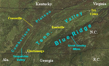
| 描述 | Satellite image showing the major topographical features of East Tennessee. |
| 日期 | (image); 2009-08 (annotation) |
| 来源 | [http://rapidfire.sci.gsfc.nasa.gov/gallery/ NASA MODIS Rapid Response System |
| 作者 | NASA (image); Brian Stansberry (annotation) |
许可协议
| 本文件完全由NASA创作,在美国属于公有领域。根据NASA的版权方针,NASA的材料除非另有声明否则不受版权保护。(参见Template:PD-USGov/zh、NASA版权方针页面或JPL图片使用方针。) | ||
 |
警告:
|
文件历史
点击某个日期/时间查看对应时刻的文件。
| 日期/时间 | 缩略图 | 大小 | 用户 | 备注 | |
|---|---|---|---|---|---|
| 当前 | 2009年8月18日 (二) 21:57 | | 434 × 264(238 KB) | BrineStans | {{Information |Description=Satellite image showing the major topographical features of East Tennessee. |Source=[http://rapidfire.sci.gsfc.nasa.gov/gallery/ NASA MODIS Rapid Response System |Date=2004-12 (image); 2009-08 (annotation) |Author=NASA (image) |
文件用途
以下2个页面使用本文件:
全域文件用途
以下其他wiki使用此文件:
- en.wikipedia.org上的用途