
File:Bosumtwi Worldwind SW.jpg

本预览的尺寸:800 × 584像素。 其他分辨率:320 × 234像素 | 640 × 467像素 | 857 × 626像素。
原始文件 (857 × 626像素,文件大小:130 KB,MIME类型:image/jpeg)
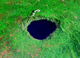
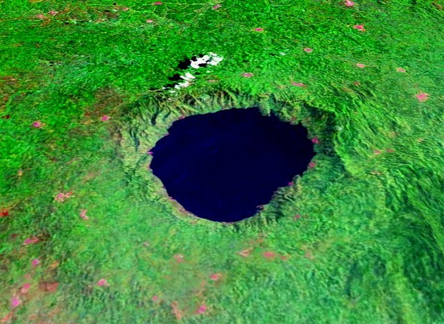
| 描述 | Lake Bosumtwi, Ghana, view from Southwest. Bosumtwiis a lake-filled impact crater, about 10.5 km in size an 1.3 million years old. Vertical exaggeration 3x. |
| 来源 | Created with NASA WorldWind by User:Vesta using Landsat 7 (false color) satellite image. |
| 作者 | User:Vesta |
6°30′26″N 1°24′24″W / 6.50722°N 1.40667°W
| 本圖像屬於公有領域,因其為NASA的World Wind衛星地圖瀏覽器的一張截圖,且使用了公有領域圖層,如Blue Marble、MODIS、Landsat、SRTM、USGS、GLOBE等。
|
 |
文件历史
点击某个日期/时间查看对应时刻的文件。
| 日期/时间 | 缩略图 | 大小 | 用户 | 备注 | |
|---|---|---|---|---|---|
| 当前 | 2006年1月7日 (六) 18:18 | | 857 × 626(130 KB) | Vesta~commonswiki | *'''Description:''' Lake Bosumtwi, view from Southwest. Vertical exaggeration 3x. *'''Source:''' Created with NASA WorldWind by User:Vesta using Landsat 7 (false color) satellite image. {{PD-WorldWind}} Category:Impact craters |
文件用途
以下页面使用本文件:
全域文件用途
以下其他wiki使用此文件:
- af.wikipedia.org上的用途
- als.wikipedia.org上的用途
- ar.wikipedia.org上的用途
- ast.wikipedia.org上的用途
- ceb.wikipedia.org上的用途
- cs.wikipedia.org上的用途
- cv.wikipedia.org上的用途
- da.wikipedia.org上的用途
- de.wikipedia.org上的用途
- en.wikipedia.org上的用途
- en.wikiversity.org上的用途
- eo.wikipedia.org上的用途
- es.wikipedia.org上的用途
- et.wikipedia.org上的用途
- eu.wikipedia.org上的用途
- fi.wikipedia.org上的用途
- fr.wikipedia.org上的用途
- ha.wikipedia.org上的用途
- hr.wikipedia.org上的用途
- hy.wikipedia.org上的用途
- id.wikipedia.org上的用途
- it.wikipedia.org上的用途
- ja.wikipedia.org上的用途
- ka.wikipedia.org上的用途
- ml.wikipedia.org上的用途
- my.wikipedia.org上的用途
- nl.wikipedia.org上的用途
- nn.wikipedia.org上的用途
- pl.wikipedia.org上的用途
- pt.wikipedia.org上的用途
- ru.wikipedia.org上的用途
- sh.wikipedia.org上的用途
- sl.wikipedia.org上的用途
查看本文件的更多全域用途。