
File:2022 Oklahoma gubernatorial election results map by congressional district.svg

此SVG文件的PNG预览的大小:800 × 399像素。 其他分辨率:320 × 160像素 | 640 × 319像素 | 1,024 × 511像素 | 1,280 × 638像素 | 2,560 × 1,277像素 | 810 × 404像素。
原始文件 (SVG文件,尺寸为810 × 404像素,文件大小:620 KB)
摘要
| 描述 |
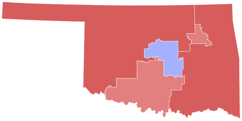
English: Results of the 2020 United States presidential election in Oklahoma. Data from the Oklahoma State Election Board. Congressional district shapefile from the University of Oklahoma Center for Spatial Analysis. Early and absentee votes in Oklahoma County and Tulsa County were formulaically allocated to the precinct level based on election day results. Precinct results were aggregated to acquire congressional district results. |
| 日期 | |
| 来源 | 自己的作品 |
| 作者 | Master of Time |
许可协议
我,本作品著作权人,特此采用以下许可协议发表本作品:
本文件采用知识共享署名-相同方式共享 4.0 国际许可协议授权。
- 您可以自由地:
- 共享 – 复制、发行并传播本作品
- 修改 – 改编作品
- 惟须遵守下列条件:
- 署名 – 您必须对作品进行署名,提供授权条款的链接,并说明是否对原始内容进行了更改。您可以用任何合理的方式来署名,但不得以任何方式表明许可人认可您或您的使用。
- 相同方式共享 – 如果您再混合、转换或者基于本作品进行创作,您必须以与原先许可协议相同或相兼容的许可协议分发您贡献的作品。
文件历史
点击某个日期/时间查看对应时刻的文件。
| 日期/时间 | 缩略图 | 大小 | 用户 | 备注 | |
|---|---|---|---|---|---|
| 当前 | 2023年9月27日 (三) 14:59 | | 810 × 404(620 KB) | Putitonamap98 | shapes |
| 2023年7月16日 (日) 02:05 |  | 810 × 404(628 KB) | CrookCoMaps61 | Shapes | |
| 2022年11月9日 (三) 10:45 |  | 3,784 × 1,923(1,016 KB) | Master of Time | == {{int:filedesc}} == {{Information |description={{en|1=Results of the 2020 United States presidential election in Oklahoma. [https://results.okelections.us/OKER/?elecDate=20221108 Data from the Oklahoma State Election Board]. Congressional district shapefile from the University of Oklahoma Center for Spatial Analysis. Early and absentee votes in Oklahoma County and Tulsa County were formulaically allocated to the precinct level base... |
文件用途
以下页面使用本文件:
全域文件用途
以下其他wiki使用此文件:
- en.wikipedia.org上的用途